East Coast beaches like this one on New York's venerable Coney Island have seen faster than normal sea level rise, likely due to climate change.
It’s usually a bad idea to generalize too much about anything – particularly science, where different selection pressures and environmental one-offs can tweak a basic model into something quite out of the ordinary. Take sea level rise, an oft-used proxy for global warming. According to scientists at the U. S. Geological Survey (USGS), those living along the U.S. Atlantic Coast can expect sea levels near them to increase faster than the 0.6 to 1.0 millimeter rise we see more broadly across the world each year.
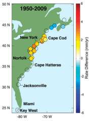
The specific spot where the oceans are rising faster than they are globally covers a 600-mile stretch from Cape Hatteras, North Carolina to Boston, Massachusetts. This stretch, which scientists nickname a “northeast hotspot,” experienced an increase in the rate of sea level rise three to four times higher than the global average between 1950-1979 and 1980-2009.
(MORE: How Climate Change Is Growing Forests In the Arctic)
“It’s a dynamic sea level rise,” study co-author and oceanographer Asbury Sallenger said. “The ocean won’t fill up like a bathtub in a very predictable kind of way…there will be regional variability in sea level rise.”
While it seems intuitive that the rate of sea level rise would be relatively constant around the globe as glaciers and ice caps melt and raise ocean water volume, there are other things that override this eustatic change. Sea levels have typically been low near the east coast of North America, particularly along the very stretch examined in this study. This is because the salty, dense water moving north to Canada and Greenland along the east coast sinks as it loses heat to the atmosphere, and then moves equatorward in a loop of heat transfer called the Atlantic Meridional Overturning Current, or AMOC – thus keeping sea levels low. But global warming up in the Arctic – where average temperatures are increasing twice as quickly as they are in the rest of the world – is melting polar and Greenland ice, and the freshwater from these melts settles on top of the saltwater because of the low salt content and thus low density of freshwater. This insulates the northward-moving water from losing heat to the atmosphere so that it can’t sink and move south as it usually does.
“The whole process slows down,” study co-author and oceanographer Peter Howd said.
The scientists determined how fast sea levels were rising in their hotspot by analyzing tide-gauge records along the North American Atlantic coast. Using this field data helped them to determine whether sea level rise was, in fact, behaving as previous models had predicted it to (it was). They then tried to answer what might have caused the hotspot by correlating the faster rate of sea level rise with several climate related parameters, mostly relating to temperature – and found significant correlations between acceleration of sea level and acceleration of temperature parameters. “It didn’t really matter which ones we picked,” Howd said.
(MORE: Top 10 Priorities for a Planet in Peril)
So what does this hotspot mean for anyone who lives between Cape Hatteras and Boston? According to Howd, the amount of sea level rise in the hotspot may increase the intermittent flooding of coastal areas associated with small to medium storm surges on the Atlantic coast. “The impact the public will see first is more frequent storm-related flooding, even if the storms aren’t more intense,” he explained. “Your house won’t fall in because one of them comes in, but your first floor might get wet, or your car might get flooded.”
That’s not catastrophic on the scale of disasters like Hurricane Katrina by any means. But the idea that sea level rise will not climb at the same rate in every location around the world does have potential policy implications, Sallenger said.
“If you assume that over 100 years global sea level rise will rise by about a meter…20 to 30 percent more will be added in some areas,” he explained. “It doesn’t mandate any particular policy, but it’s a result that should be in the mix of all results.” Hopefully such results will continue to flow freely, what with North Carolina’s recent crackdown on predictions of sea level rise except those “consistent with historic trends” – which essentially bans climate modeling, because it wouldn’t be consistent with historic trends – and Virginia’s ruling that scientists excise “code words” like “sea level rise” and “climate change” from studies on climate change. Several websites are thankfully helping to put the information out there; Climate Central has a map that lets you type in your zip code to get a sense of your own risk from sea level rise, for example. But it would be great to see more political effort to make the public aware of rising risks, if they exist, and policies that consider the variabilities in the complex machine that is our planet.
MORE: A U.N. Report Shows How Far We Have to Go to Save the Planet
Tara Thean is a contributor at TIME. Find him on Twitter at @tarathean. You can also continue the discussion on TIME’s Facebook page and on Twitter at @TIME.


