The lidless eyes of the satellites circle the Earth, looking down upon the surface. The images that satellites like the U.S. Geological Survey’s Landsat 7 become instant feedback about our effect on the planet, how the Earth is shaped by processes both human and natural. But as this collection of photos from an exhibition at the Library of Congress in Washington shows, satellite image can be made into art as well. Band combinations and shades in these Landsat images were optimized to dramatize their appearance, to show off the colors and the contrasts of the Earth. The result is breathtaking.
The Earth as Art: Satellite Images of Our Planet from Orbit

USGA / NASA
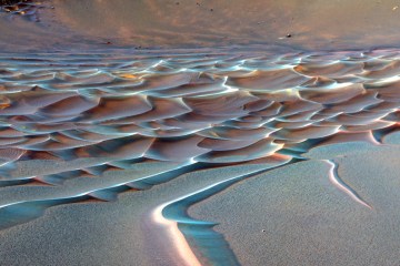
GREAT SALT DESSERT, IRAN - Like poster paints run wild, this image reveals a montage of landscapes in Iran's largest desert, the Dasht-e Kavir, or Great Salt Desert. The almost uninhabited region covers an area of over 29,730 sq m and is a mix of dry streambeds, desert plateaus, mudflats, and salt marshes.